
Hike Report for Avery Peak
Avery Peak is located in Maine, United States. It has an elevation of 1243 meters above sea level. It is located at the following coordinates: (45.1466, -70.2758).
This hike report was written by Douglas Twitchell, about a hike on Monday, September 5, 2005.
Not enough votes to display a rating
Directions to Trailhead
If you're planning to hike the Firewarden's Trail, you need to head up Route 27 past Kingfield toward Stratton. About 3 miles past the Sugarloaf entrance you'll find the Stratton Brook Road on the right. This is a dirt road that leads to most of the Bigelow Mountain hiking trails. When I hiked Cranberry Peak earlier in the summer the Stratton Brook Road was not well marked, but now there is a new sign up, so it was much easier to find. Drive in on this road about a mile, and you'll see a small parking area; this is where you should park if you are doing the Appalachian Trail. But if you are hiking Avery Peak, continue on another six tenths of a mile, and you'll find, right where the road turns from a dirt road to an almost impassable track, a small parking area. This is where you should park.
Hike Report
There were three of us who went on this hike; me, my brother, and his wife.
We hadn't been going more than 15 minutes when we met a father and son coming down off the trail. They asked where we were headed, and we told them. The father looks at us and says, "You know, that's a pretty steep trail." Yes, we'd heard that. "That's alright," he said, "you can do it, everyone does. Just take your time." Good advice, which we had already agreed on; we weren't going to push ourselves when we got to the steep part, just take it slow and easy, because we had given ourselves all day for this hike.
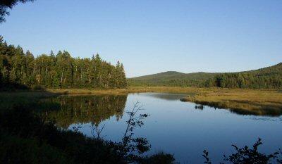
About that time we passed the Stratton Brook Pond, which is a beautiful little pond with nice views of the mountains all around.
The first part of the hike was very easy; it was mostly a gradual upgrade, which made for a very nice, relaxing, hike through the woods, with just a few slightly steeper sections.
We took my brother's GPS unit with us, so we would know exactly where we were in relation to our starting point and our destination. This made the hike quite interesting, because we could track how far we had hiked, and (as the crow flies) how much further we had to go. It turns out that the Firewarden's Trail is almost "as the crow flies" - if you look at a map you'll see it's a very direct route to the summit.
The GPS gave us elevations as well as latitude/longitude, which was also interesting. We started out in the parking lot at about 1350, and the summit of Avery Peak is 4088, so we knew we had a lot of elevation to gain...about 2700 feet. And as we hiked, we kept thinking, "When exactly is this elevation gain going to happen?" Because we hiked the first 2.3 miles (to the junction of the Horns Pond Trail) and saw very little elevation gain. We hiked another 1.2 miles and still saw little elevation gain.
We hiked two thirds of the distance in about two hours, and then it seemed like we hit a brick wall. The trail turns steep at that point. Not so steep that you're using your hands to clamber over boulders, but it was an unrelenting steepness. It just kept going up and up without any break.
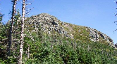
At one point we broke out of the trees long enough to get a glimpse of what we thought was Avery Peak, but we later decided it was probably a false peak.
At 4.6 miles (the junction with the Horns Pond trail is exactly half way up the Firewarden's Trail...2.3 miles before, 2.3 miles after) we intersected the Appalachian Trail, and had the choice of heading toward West Peak or Avery Peak. West Peak is the tallest of the Bigelow Mountain Range peaks, but we had been told that even though it was tallest, Avery's views were best. So we turned to the right and headed toward Avery. After hiking a few minutes we were able to turn around and get a good view of West Peak behind us, and Flagstaff Lake to our North.
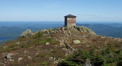
For the last .4 miles of our hike (from the junction of the Appalachian Trail to the peak) there was a bit more bouldering, but we finally reached the peak, and asked another hiker (who had been hiking the Appalachian Trail for a few weeks, and had about a week and a half of hiking ahead of him) to snap a picture of us to prove we'd actually been there.
The views from the top of Avery Peak are amazing and phenomenal - views 360 degrees around. Flagstaff lake, West Peak, Carabassett Valley and Sugarloaf, and much much more.
Near the firewarden's tower there is a sign which reads:
Myron H. Avery Peak
Of Mt. Bigelow
Named In Honor Of
Myron Haliburton Avery
1899 - 1952
Whose Foresight Leadership and Diligence
Made Possible
The Appalachian Trail
This 2,000 Mile Footpath
From Maine To Georgia
And finally we turned around and headed back home. It was much easier going down; the hike up took us 4 hours and 45 minutes, but on the way down it took us just about 3 hours.
We hadn't been going more than 15 minutes when we met a father and son coming down off the trail. They asked where we were headed, and we told them. The father looks at us and says, "You know, that's a pretty steep trail." Yes, we'd heard that. "That's alright," he said, "you can do it, everyone does. Just take your time." Good advice, which we had already agreed on; we weren't going to push ourselves when we got to the steep part, just take it slow and easy, because we had given ourselves all day for this hike.
About that time we passed the Stratton Brook Pond, which is a beautiful little pond with nice views of the mountains all around.
The first part of the hike was very easy; it was mostly a gradual upgrade, which made for a very nice, relaxing, hike through the woods, with just a few slightly steeper sections.
We took my brother's GPS unit with us, so we would know exactly where we were in relation to our starting point and our destination. This made the hike quite interesting, because we could track how far we had hiked, and (as the crow flies) how much further we had to go. It turns out that the Firewarden's Trail is almost "as the crow flies" - if you look at a map you'll see it's a very direct route to the summit.
The GPS gave us elevations as well as latitude/longitude, which was also interesting. We started out in the parking lot at about 1350, and the summit of Avery Peak is 4088, so we knew we had a lot of elevation to gain...about 2700 feet. And as we hiked, we kept thinking, "When exactly is this elevation gain going to happen?" Because we hiked the first 2.3 miles (to the junction of the Horns Pond Trail) and saw very little elevation gain. We hiked another 1.2 miles and still saw little elevation gain.
We hiked two thirds of the distance in about two hours, and then it seemed like we hit a brick wall. The trail turns steep at that point. Not so steep that you're using your hands to clamber over boulders, but it was an unrelenting steepness. It just kept going up and up without any break.
At one point we broke out of the trees long enough to get a glimpse of what we thought was Avery Peak, but we later decided it was probably a false peak.
At 4.6 miles (the junction with the Horns Pond trail is exactly half way up the Firewarden's Trail...2.3 miles before, 2.3 miles after) we intersected the Appalachian Trail, and had the choice of heading toward West Peak or Avery Peak. West Peak is the tallest of the Bigelow Mountain Range peaks, but we had been told that even though it was tallest, Avery's views were best. So we turned to the right and headed toward Avery. After hiking a few minutes we were able to turn around and get a good view of West Peak behind us, and Flagstaff Lake to our North.
For the last .4 miles of our hike (from the junction of the Appalachian Trail to the peak) there was a bit more bouldering, but we finally reached the peak, and asked another hiker (who had been hiking the Appalachian Trail for a few weeks, and had about a week and a half of hiking ahead of him) to snap a picture of us to prove we'd actually been there.
The views from the top of Avery Peak are amazing and phenomenal - views 360 degrees around. Flagstaff lake, West Peak, Carabassett Valley and Sugarloaf, and much much more.
Near the firewarden's tower there is a sign which reads:
Myron H. Avery Peak
Of Mt. Bigelow
Named In Honor Of
Myron Haliburton Avery
1899 - 1952
Whose Foresight Leadership and Diligence
Made Possible
The Appalachian Trail
This 2,000 Mile Footpath
From Maine To Georgia
And finally we turned around and headed back home. It was much easier going down; the hike up took us 4 hours and 45 minutes, but on the way down it took us just about 3 hours.
Difficulty
I would not recommend this hike for families with young children. The first two thirds of the hike is relatively easy, without long steep stretches, but at about 3.6 miles into the hike, it feels like you've hit a brick wall, with the steepness increasing, and never relenting until you're close to the Appalachian Trail Junction.
You don't need to be in top physical condition to do this hike, but if you aren't, plan on taking lots of time, and resting very often during the last mile of the hike.
You don't need to be in top physical condition to do this hike, but if you aren't, plan on taking lots of time, and resting very often during the last mile of the hike.
Statistics
Our elevation gain was about 2700 ft - from around 1300 ft at the parking area to 4088 ft at the peak. The distance hiked from the parking area to Avery Peak was approximately 5 miles. Most of the elevation gain was in the last mile. We took 4.75 hours up, and 3 hours down.
Images

Images on this page are the property of Douglas Twitchell, and may not be used without permission of the owner.

