
Hike Report for Pleasant Mountain
Pleasant Mountain is located in Maine, United States. It has an elevation of 612 meters above sea level. It is located at the following coordinates: (44.027, -70.8223).
This hike report was written by Douglas Twitchell, about a hike on Tuesday, May 30, 2006.
Not enough votes to display a rating
Directions to Trailhead
If you are heading West from Bridgton, follow 302 until you cross the town line into Fryeburg. One half-mile into Fryeburg, you will see the Wilton Warren Road on the left. Take this road. Follow the Wilton Warren Road for a little over a mile. You will cross a small bridge (posted: 3 tons). Very soon after that you will see a small unpaved parking area on the left of the road. Park here. The firewarden's trail head is just beyond the parking area, on the same side of the road.
Hike Report
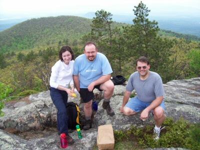
My brother and his wife and I hiked Pleasant Mountain Saturday of Memorial weekend. The weather reports said it might shower in the morning, but would gradually turn sunny.
Since we weren't in a hurry to get started, we waited until a little later in the day to hike; we started hiking just after noon.
The trail was fairly easy for most of the hike. Even with the large amounts of rain we've had recently, we didn't encounter very much mud. Mostly the hike was a very gradual climb, so we didn't need to stop for rest very often, and made good time to the peak - less than two hours.
If you are looking for a well blazed trail, this is not it. We saw a grand total of maybe three or four blue blazes on trees, and mostly those occurred in places where it was obvious where we should go.
There are several "forks" in the trail, and most of these forks are unmarked. One fork was marked with a sign that was hidden under some branches - we didn't see it until the return trip. However, our general rule of thumb was: when faced with a fork, take the trail more travelled. In this case, the rule of thumb worked out nicely.
There are no views whatsoever along the trail - you have to wait until you arrive at the peak to see anything interesting. You can't even see the peak itself until you are practically on top of it.
Near the peak there is a trail labeled "Bald Peak", which goes to the left. We did not explore this trail, as we had no idea how long it would take to get to Bald Peak. But when you reach this trail, you are almost to the peak.
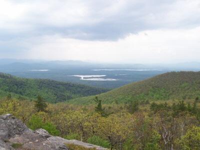
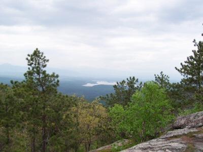
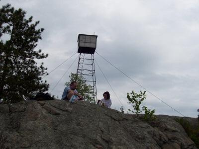
At the peak there is a firewarden's tower (still standing, as of 2006, but all boarded up). There are also nice views of ponds and mountains across about a 180 degree span.
There is also a plaque at the peak, in memory of Robert "Bob" Barton, Jr. who died in 2005. The plaque contains the following quote:
"Climb the mountains and get their good tidings. The winds will blow their own freshness into you and the storms their energy, while cares will drop away from you like the leaves of autumn." - Muir
A couple with two dogs, and a woman reading a book were at the peak when we arrived. We sat and ate our lunch, enjoyed the views, and then turned around and headed back home.
On the way down, we met many hikers, who had waited even longer to start hiking. Lucky for them, they got a sunnier peak experience than we did.
Since we weren't in a hurry to get started, we waited until a little later in the day to hike; we started hiking just after noon.
The trail was fairly easy for most of the hike. Even with the large amounts of rain we've had recently, we didn't encounter very much mud. Mostly the hike was a very gradual climb, so we didn't need to stop for rest very often, and made good time to the peak - less than two hours.
If you are looking for a well blazed trail, this is not it. We saw a grand total of maybe three or four blue blazes on trees, and mostly those occurred in places where it was obvious where we should go.
There are several "forks" in the trail, and most of these forks are unmarked. One fork was marked with a sign that was hidden under some branches - we didn't see it until the return trip. However, our general rule of thumb was: when faced with a fork, take the trail more travelled. In this case, the rule of thumb worked out nicely.
There are no views whatsoever along the trail - you have to wait until you arrive at the peak to see anything interesting. You can't even see the peak itself until you are practically on top of it.
Near the peak there is a trail labeled "Bald Peak", which goes to the left. We did not explore this trail, as we had no idea how long it would take to get to Bald Peak. But when you reach this trail, you are almost to the peak.
At the peak there is a firewarden's tower (still standing, as of 2006, but all boarded up). There are also nice views of ponds and mountains across about a 180 degree span.
There is also a plaque at the peak, in memory of Robert "Bob" Barton, Jr. who died in 2005. The plaque contains the following quote:
"Climb the mountains and get their good tidings. The winds will blow their own freshness into you and the storms their energy, while cares will drop away from you like the leaves of autumn." - Muir
A couple with two dogs, and a woman reading a book were at the peak when we arrived. We sat and ate our lunch, enjoyed the views, and then turned around and headed back home.
On the way down, we met many hikers, who had waited even longer to start hiking. Lucky for them, they got a sunnier peak experience than we did.
Difficulty
This was a fairly easy hike. A gradual slope most of the way up. The only thing that made this hike difficult was the fact that we've had fairly rainy weather. For parts of the hike you are walking across smooth, sloped bolders, and these were quite slippery. Towards the end of the hike we were actually hiking in the edge of the woods next to the trail, to avoid the slippery rocks. On a dry day, however, this should be a good hike for the whole family.
Statistics
The firewarden's trail length is 2.5 miles. It took us just a little under two hours to hike up, and a little more than one hour to hike back down. The total elevation gain is 1600 feet.
Images
Images on this page are the property of Douglas Twitchell, and may not be used without permission of the owner.

