Hike Report for Baldpate Mountain
Baldpate Mountain is located in Maine, United States. It has an elevation of 1154 meters above sea level. It is located at the following coordinates: (44.6092, -70.8924).
This hike report was written by Douglas Twitchell, about a hike on Tuesday, October 16, 2007.
Not enough votes to display a rating
Directions to Trailhead
The hike we did requires two vehicles. One of them needs to be parked on the East B Hill Road between Andover and Newry. NOTE: There are two trailheads on East B Hill Road. One is the Appalacian Trail, the other is a trail which goes by The Cataracts.
If you are starting from Andover, the Cataracts trailhead is approximately 5.5 miles from the intersection of Rte 5 and the East B Hill Road. The Appalachian Trail is 2.5 miles further down that road (or 8 miles from Rte 5).
Once you have parked at one of these trailheads, drive the other vehicle to Grafton Notch State Park. You'll continue on East B Hill Road until you reach Rte 26 in Upton. Turn left here, toward Newry, until you see signs for Grafton Notch State Park. On your right there will be a parking lot. Park there to begin your hike. Cross the road to the big AT (Appalachian Trail) marker.
Hike Report
I did this hike on Oct 15, 2007, with two friends of mine - Bobby and Ben. We hit the trail at about 6:50 AM. We expected to take most of the day on this hike, so started early. The parking lot at Grafton Notch was deserted, which I had never seen before!
It was a chilly, cloudy morning, and we were skeptical that we would see any good views (we were sort of right!). When you start out on the trail up to Baldpate, you won't have gone very far before you find a fork which lets you go off the AT to climb Table Rock. We did not take this trail, because Ben said it was quite steep, and we would want to save that energy for later in the day. So we continued on the AT, and eventually came to a second fork which allowed you to take a 0.5 mile detour to the top of Table Rock. We did this.
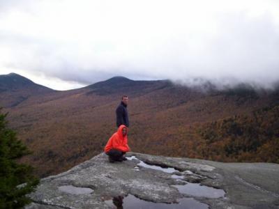
Table Rock is amazing (even on a cloudy, misty day). You have about a 900 foot sheer drop to Route 26, and views of Old Speck and other mountains. It was strange to be so close to a mountain as big as Old Speck and not be able to see its peak.
We returned to the AT, and when we arrived there, the whole trip so far had taken about an hour.
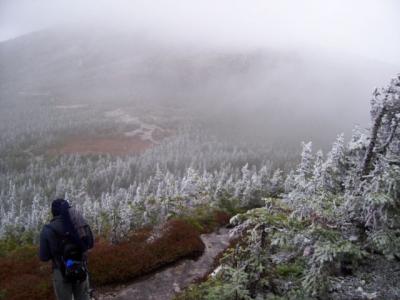
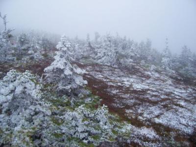
Continuing on the AT, we began ascending West Baldpate, the shorter of the two Baldpate peaks. This part of the hike was made difficult by the fact that it started to drizzle, and snow, and it was just cold enough that there was ice forming on the rocks, and icicles dripping off the sides. As we continued on, we saw more and more trees that were partly white. Not snow - ice was forming on the branches and needles.
We reached the peak of West Baldpate before 10:30, and were disappointed by the actual peak itself; you're in the woods, and there isn't much to see. However, as you continue on, eventually you reach a spot a little lower on the other side where you can see some views.
At least...we COULD have seen views if it wasn't so cloudy. Honestly, I don't remember when I've seen such a strange sight - we were on top of a mountain and the fog was so thick that it was like someone had hung a white curtain all around the mountain top. It was very eerie.
We didn't stay long there, because the wind was blowing, and it was quite cold. We continued on toward Baldpate. There is little elevation loss and gain between the two peaks, so on a clear sunny day I don't think it would have been difficult.
But as we were climbing Baldpate, eventually we came out of the trees (not surprisingly, the peak of Baldpate is bald!) and as we did the wind was whipping at us, and blowing sleet and freezing rain right into the sides of our faces. As we climbed up over boulders, there were three things I was thinking: one was, I wanted to find large boulders to shelter behind for a few minutes. Two was, the last time I had experienced winds this strong, I was on top of Mount Washington, and three: I was more conscious than I've ever been that it would be very very easy to seriously injure ourselves on this hike. (Don't worry, mom - we didn't!) ;)
We reached the peak of Baldpate around 11:30. The peak is actually flat, so it takes awhile to walk across it. Ben commented that it reminded him of winter in Narnia. I thought that was a pretty good description - I just kept thinking, it felt unreal. We were still in the clouds, but all around us were shrubby little Christmas trees covered with snow.
The hike down Baldpate was much easier than the hike up, since we were sheltered from the wind on the other side, and we quickly got back into the woods. It is a fairly steep incline on the way down, made more difficult by the fact that all the rocks were wet...but we were so relieved to be out of the wind and the sleet that we didn't complain.
About a half an hour later we hit the junction of the Appalachian Trail and the shorter trail that would lead us back to The Cataracts. Go straight to stay on the AT, and turn right, to head toward The Cataracts. We turned right.
This trail was marked with blue blazes, and not as well maintained, but it was not a hard hike...just a shallow downhill walk through the woods.
We finally came out of the woods to the East B Hill Road at about 2:00. And to our dismay...
...discovered that it was NOT the trailhead we THOUGHT it was...and our vehicle had been parked 2.5 miles up the road.
So our short cut ended up not being a short cut after all! If you do this hike, be SURE you know which trailhead you're parked at!
This was such an unusual hike for me that it inspired me to write a little freeverse poem, which I posted here: October Climb
Difficulty
This hike, on the day we did it, was almost brutal in its difficulty. This was because we chose to hike on a day in mid October, and there was a combination of rain, snow, and sleet along the way, with very strong winds.
I suspect that on a clear summer day, this would not be overly difficult (aside from the fact that it's quite long). There are some steep sections, but plenty of long stretches that are either flat or have a shallow slope.
If you have children with you, doing a trip to Table Rock and back is probably better than trying to do the entire trip across both Baldpates. IMPORTANT NOTE: parents should be aware that while Table Rock has magnificent views, there are no railings around the edge, and there is a 900 foot sheer drop.
Statistics
This hike will take you from Newry to Andover. It is a long hike. Depending on whether you take the Appalachian Trail all the way, or take the "short cut", it's either 10 or 8 miles. We took the "short cut", and it took us about seven hours. We guess that we would have taken another hour if we had stayed on the AT.
Along the way you'll have the option of detouring to see Table Rock, a plateau with a 900 ft sheer drop.
West Baldpate is a mountain peak with an elevation of about 3600. Baldpate is about 3800.
Along the way you'll have the option of detouring to see Table Rock, a plateau with a 900 ft sheer drop.
West Baldpate is a mountain peak with an elevation of about 3600. Baldpate is about 3800.
Images


Images on this page are the property of Douglas Twitchell, and may not be used without permission of the owner.


