
Hike Report for Tumbledown Mountain
Tumbledown Mountain is located in Maine, United States. It has an elevation of 931 meters above sea level. It is located at the following coordinates: (44.7501, -70.5488).
This hike report was written by Douglas Twitchell, about a hike on Thursday, August 21, 2008.
This report describes a hike on Parker Ridge Trail
This report describes a hike on Parker Ridge Trail
Not enough votes to display a rating
Directions to Parker Ridge Trail
When you reach the intersection of 156 and 142, head north on 142 for about 2.5 miles. You will see "Byron Road" to your left. More noticeably, this is the turn to get to Webb Beach. Turn here and follow this road for about a half a mile. Byron Road veers left here, but you will continue straight (currently a dirt road) for 2 miles. After two miles you'll see "Morgan Road". Turn right onto Morgan Road and follow it to the parking area. (The parking area isn't much of a parking area, but you'll know you're there because it's on the right just about the time you'll be thinking "I really don't want to drive my car any further on this horrid road!") Now continue on straight on foot. Eventually this path will fork. The right fork takes you to Little Jackson while the left fork takes you up the Parker Ridge Trail to Tumbledown Mountain.
Hike Report
My friends Ben and Melissa did this hike with me, We hit the trail at about 11:10 in the morning. We hiked for just a few minutes before we came to the fork between the Tumbledown Trail and the Little Jackson Trail. We went left here, and did a bit of downhill (who wants to do that when you're just starting out a hike?). We came to a stream that we had to jump across rocks to cross, and then we began the uphill.
At first the slope was gradual, and it was a pleasant and easy walk through the woods. After about a mile, though, the incline started to increase dramatically, and the going gets a bit tougher.
Pay close attention to the blue blazes; they're there, but they're not always close together, and sometimes there are a couple ways that look like they might be the right way to go.
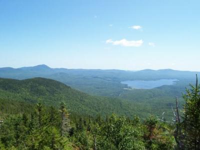
When you start to come out of the trees and up onto the boulders, be sure to look behind you; there's a great view of Webb Lake and Mount Blue.
From this point on, you'll continue getting a series of nice views of mountains both distant and close all the way to the summit.
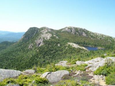
As you come up over the ridge, you'll be delighted (and perhaps a bit dismayed) by the view of Tumbledown Pond below you, and Tumbledown's summit on the far side. Delighted, because it's a beautiful sight. Dismayed because it looks like a long, long way to the summit.
From your first view of the pond it'll only take you fifteen minutes to get to the pond, and from there, it'll only take you a half an hour to get to the summit.
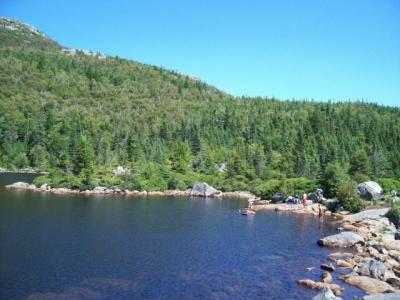
Many people go swimming in the pond, but Ben and Melissa and I did not. We sat on the rocks by the water and ate our lunch, and then continued on to the summit.
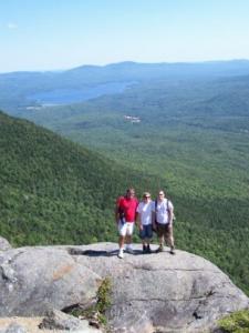
I think a lot of people go to the lake, but don't bother going to the summit, and they're really missing out by skipping the summit. I think what I liked most about the summit is the sense of distance and solitude and quiet as you sit on the top and look at the mountains all around. A lovely spot.
After just sitting on the rocks and enjoying the quietness and beauty of the place, we turned around and headed home.
The hike down goes much quicker than the hike up, and we were back to the trailhead less than six hours from when we started.
At first the slope was gradual, and it was a pleasant and easy walk through the woods. After about a mile, though, the incline started to increase dramatically, and the going gets a bit tougher.
Pay close attention to the blue blazes; they're there, but they're not always close together, and sometimes there are a couple ways that look like they might be the right way to go.
When you start to come out of the trees and up onto the boulders, be sure to look behind you; there's a great view of Webb Lake and Mount Blue.
From this point on, you'll continue getting a series of nice views of mountains both distant and close all the way to the summit.
As you come up over the ridge, you'll be delighted (and perhaps a bit dismayed) by the view of Tumbledown Pond below you, and Tumbledown's summit on the far side. Delighted, because it's a beautiful sight. Dismayed because it looks like a long, long way to the summit.
From your first view of the pond it'll only take you fifteen minutes to get to the pond, and from there, it'll only take you a half an hour to get to the summit.
Many people go swimming in the pond, but Ben and Melissa and I did not. We sat on the rocks by the water and ate our lunch, and then continued on to the summit.
I think a lot of people go to the lake, but don't bother going to the summit, and they're really missing out by skipping the summit. I think what I liked most about the summit is the sense of distance and solitude and quiet as you sit on the top and look at the mountains all around. A lovely spot.
After just sitting on the rocks and enjoying the quietness and beauty of the place, we turned around and headed home.
The hike down goes much quicker than the hike up, and we were back to the trailhead less than six hours from when we started.
Difficulty
Of the 15 hikes I've done this summer, this was not the longest, but it was the hardest. But it was definitely worth it for the views at the top. We did see some children at the pond, so clearly it is done as a family hike, but you will want to make sure children are in good shape, and prepared for a bit of hard work.
Statistics
We took about 5 hours and 45 minutes (including rest time, lunch time, and time to enjoy the views at the summit) round trip. Our elevation gain was just under 2000 feet, and our distance hiked was just under three miles (one way). The distance hiked to the pond was about 2.5 miles.
Images
Images on this page are the property of Douglas Twitchell, and may not be used without permission of the owner.

