
Hike Report for Mount Cutler
Mount Cutler is located in Maine, United States. It has an elevation of 375 meters above sea level. It is located at the following coordinates: (43.8729, -70.8246).
This hike report was written by Douglas Twitchell, about a hike on Friday, August 22, 2008.
Not enough votes to display a rating
Directions to Trailhead
Follow Route 117 south into Hiram. Where Route 117 intersects Route 113, turn right to cross the bridge. Immediately after crossing the bridge, turn left. Watch for the "Mountain View Ave" almost immediately on the right, and take this road. You'll turn a corner, and then see a parking lot next to some railroad tracks. Park there. From there, walk down the tracks just a little, and you'll see the Cutler Trail.
Hike Report
My friend Nate and I started this hike with little information besides what the Maine Atlas and Gazetteer said, and it turned out that information wasn't entirely useful.
We were pleasantly surprised, as we started hiking, to be joined by a local dog who tagged along with us the whole way to the summit - even over the steepest of sections.
The trail is quite clear, and fairly well marked with red blazes on the trees and occasionally on the rocks.
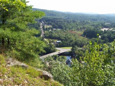
The hike up is very rugged. You'll get about 2/3 of the way up the mountain and you'll come out onto some ledges where you get nice views of the village below you.
Continue on and eventually the hike gets less steep. You will probably wonder a few times if you're actually at the summit of the mountain, because it looks like the trail continues downward.
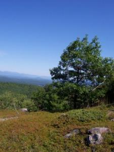
What we eventually realized is that the mountain actually has two summits with a bit of a ravine in between them. The best views are on the second summit, so you'll need to go down to get up.
When we reached the bottom of the ravine, the red-blazed trail continued north, and appeared to continue down. We were hesitant to continue along the blazed trail because we could see that it was a straight shot up the other side of the ravine. (I suspect that northbound trail circled around the summit and approached from another, gentler slope, but we didn't take the blazed trail, so I can't say for sure)
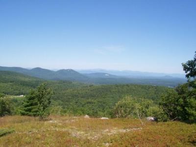
So we marked a waypoint on the GPS so we could find the trail again, and headed off away from the trail. Surprisingly, we found that there was another trail (occasionally marked with cairns, but no red paint) that went straight up over the second peak. This was a very steep climb, but the trail led us all the way up to the second summit, where we enjoyed some nice views of the White Mountains.
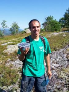
The other pleasant surprise was a wide open space just covered with ripe blueberries. Nate and I spent quite awhile just picking berries before we turned around and headed back.
After hiking Tumbledown Mountain yesterday, this hike was a bit of a letdown; the views were not at all spectacular - just nice. And it was a lot of work to get them, even though the hike was short. But the blueberries and the chance to spend a day with a friend made it worthwhile.
We were pleasantly surprised, as we started hiking, to be joined by a local dog who tagged along with us the whole way to the summit - even over the steepest of sections.
The trail is quite clear, and fairly well marked with red blazes on the trees and occasionally on the rocks.
The hike up is very rugged. You'll get about 2/3 of the way up the mountain and you'll come out onto some ledges where you get nice views of the village below you.
Continue on and eventually the hike gets less steep. You will probably wonder a few times if you're actually at the summit of the mountain, because it looks like the trail continues downward.
What we eventually realized is that the mountain actually has two summits with a bit of a ravine in between them. The best views are on the second summit, so you'll need to go down to get up.
When we reached the bottom of the ravine, the red-blazed trail continued north, and appeared to continue down. We were hesitant to continue along the blazed trail because we could see that it was a straight shot up the other side of the ravine. (I suspect that northbound trail circled around the summit and approached from another, gentler slope, but we didn't take the blazed trail, so I can't say for sure)
So we marked a waypoint on the GPS so we could find the trail again, and headed off away from the trail. Surprisingly, we found that there was another trail (occasionally marked with cairns, but no red paint) that went straight up over the second peak. This was a very steep climb, but the trail led us all the way up to the second summit, where we enjoyed some nice views of the White Mountains.
The other pleasant surprise was a wide open space just covered with ripe blueberries. Nate and I spent quite awhile just picking berries before we turned around and headed back.
After hiking Tumbledown Mountain yesterday, this hike was a bit of a letdown; the views were not at all spectacular - just nice. And it was a lot of work to get them, even though the hike was short. But the blueberries and the chance to spend a day with a friend made it worthwhile.
Difficulty
As you start this hike you'll see a sign that warns that the trail is difficult, and you should not do it if you aren't in good physical condition. That sign isn't kidding. This is the steepest hike I've done this summer. The only thing that keeps it from being a truly difficult hike is the fact that it's not really all that long.
Young children? Be prepared for the fact that you may need to lift them up over some boulders, and that on the way down it may be a bit frightening for them, trying to climb down.
I wouldn't recommend doing this on a wet, rainy day; the ascent could be very treacherous when wet.
Young children? Be prepared for the fact that you may need to lift them up over some boulders, and that on the way down it may be a bit frightening for them, trying to climb down.
I wouldn't recommend doing this on a wet, rainy day; the ascent could be very treacherous when wet.
Statistics
We spent about 2.5 hours on this hike, which is probably more than most people spend on the trail, but I think we did something different from what most hikers do.
Images
Images on this page are the property of Douglas Twitchell, and may not be used without permission of the owner.

