
Hike Report for Monadnock Mountain
Monadnock Mountain is located in New Hampshire, United States. It has an elevation of 941 meters above sea level. It is located at the following coordinates: (42.8612, -72.1093).
This hike report was written by Douglas Twitchell, about a hike on Sunday, August 31, 2008.
Not enough votes to display a rating
Directions to Trailhead
If you are heading west out of Jaffrey, NH on route 124, go about two miles, and you will see Dublin Road on your right. Follow this road until you see Monadnock Bible Conference on the left. Just beyond this camp is the Poole Road, which takes you right to the park area.
Since I'm at Monadnock Bible Conference for the weekend as a Bible teacher, I didn't drive to the park - instead I hiked partway up the Poole Road until I got to the Hinkley Trail on the right. This is not an obvious trail, but if you are watching the woods, you'll see a sign just a few yards down the trail that says "Hinkley Trail". This trail gives you a little longer hike, but avoids the fee for the park.
However, there is nowhere to park your vehicle near this trail, so most people won't be able to do it the way I did.
Hike Report
I broke my cardinal rule this afternoon - I never go hiking alone. I always bring someone with me, just in case we have any troubles along the way. But since Monadnock is classified as the most hiked mountain in the United States, I knew there would be plenty of people around. So I set off on my own this afternoon to hike Monadnock.
I took the Hinkley trail which starts off the Poole Road, and goes about .6 miles through the woods until it intersects the Harling Trail. I turned left on Harling and followed that trail until I reached the Cascade Link Trail, which is clearly marked.
Up until this point, the hike was pretty easy - a nice gradual climb through the woods.
I followed the Cascade Link Trail all the way to the Pumpelly Trail, which is not the most common way of hiking, but I was told I would have some nice views along the way. If you take the Cascade Link Trail you will go a LONG ways out of your way, and then double back when you get to the Pumpelly Trail. But you're mostly walking along a ridge, and you do have some nice views along the way. This is also the easiest trail, because it has the least steep slopes. There were only two or three times where the trail got at all steep, and then it was not for very long.
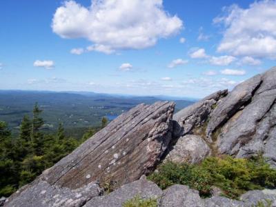
When you reach the Pumpelly Trail, you'll turn left. This trail is also clearly marked with a sign, and with cairns along the way. This trail takes you all the way to the summit. The last twenty minutes or so, you'll be clambering over boulders - this is the hardest part of the trail.
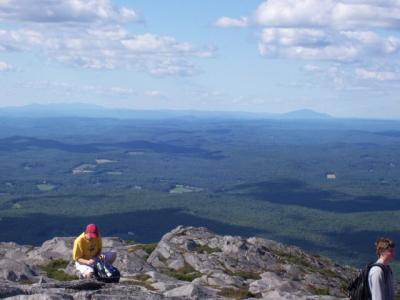
I think the most disappointing part of this hike is that the summit is crawling with people. From one spot on the summit I sat and counted 68 people who were visible to me from there. I'm sure there were about twice that many people scattered across the summit.
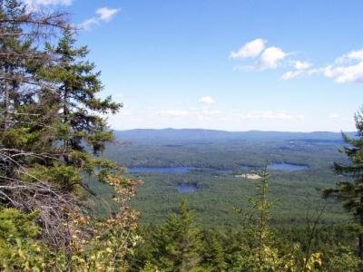
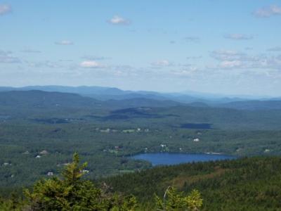
Also, though this is the most hiked mountain in the world, I was disappointed with the views. They were nice, but not fantastic, which I had been led to believe. Of course, having hiked Aziscohos (near Rangeley, Maine), Tumbledown (in Weld, Maine), and Chocorua (New Hampshire) in the last two weeks, my expectations were a bit high.
After snapping a couple pictures I headed back down. This time I took the "Red Spot" trail, which is marked with (get ready for this) Red Spots. This is a much steeper trail, but much quicker, because it is far more direct. The Red Spot trail connects back to the Cascade Link trail. Turn right onto Cascade Link, and continue on to the bottom the way you came up.
I took the Hinkley trail which starts off the Poole Road, and goes about .6 miles through the woods until it intersects the Harling Trail. I turned left on Harling and followed that trail until I reached the Cascade Link Trail, which is clearly marked.
Up until this point, the hike was pretty easy - a nice gradual climb through the woods.
I followed the Cascade Link Trail all the way to the Pumpelly Trail, which is not the most common way of hiking, but I was told I would have some nice views along the way. If you take the Cascade Link Trail you will go a LONG ways out of your way, and then double back when you get to the Pumpelly Trail. But you're mostly walking along a ridge, and you do have some nice views along the way. This is also the easiest trail, because it has the least steep slopes. There were only two or three times where the trail got at all steep, and then it was not for very long.
When you reach the Pumpelly Trail, you'll turn left. This trail is also clearly marked with a sign, and with cairns along the way. This trail takes you all the way to the summit. The last twenty minutes or so, you'll be clambering over boulders - this is the hardest part of the trail.
I think the most disappointing part of this hike is that the summit is crawling with people. From one spot on the summit I sat and counted 68 people who were visible to me from there. I'm sure there were about twice that many people scattered across the summit.
Also, though this is the most hiked mountain in the world, I was disappointed with the views. They were nice, but not fantastic, which I had been led to believe. Of course, having hiked Aziscohos (near Rangeley, Maine), Tumbledown (in Weld, Maine), and Chocorua (New Hampshire) in the last two weeks, my expectations were a bit high.
After snapping a couple pictures I headed back down. This time I took the "Red Spot" trail, which is marked with (get ready for this) Red Spots. This is a much steeper trail, but much quicker, because it is far more direct. The Red Spot trail connects back to the Cascade Link trail. Turn right onto Cascade Link, and continue on to the bottom the way you came up.
Difficulty
This is a hike that is done by entire families. In fact, it is claimed that this is the most hiked mountain in the United States, and second in the world, only to Fuji, in Japan.
Depending on the trail you take, the difficulty varies significantly. If you take the Cascade Link Trail to the Pumpelly Trail, you will hike a much longer distance, but it is not as steep.
Depending on the trail you take, the difficulty varies significantly. If you take the Cascade Link Trail to the Pumpelly Trail, you will hike a much longer distance, but it is not as steep.
Statistics
From the time I left the Monadnock Bible Conference Campground until the time I returned was almost exactly 4 hours. HOWEVER...I was hiking alone, so I rarely stopped for breaks, and while I was hiking I pushed myself pretty hard. So if you are hiking with a group, or family, expect to take longer than four hours.
The total elevation of the mountain is 3165; however, I don't know what the elevation gain was, or my distance hiked.
There are a number of trails available.
The total elevation of the mountain is 3165; however, I don't know what the elevation gain was, or my distance hiked.
There are a number of trails available.
Images
Images on this page are the property of Douglas Twitchell, and may not be used without permission of the owner.

