
Hike Report for Boundary Bald Mountain
Boundary Bald Mountain is located in Maine, United States. It has an elevation of 1105 meters above sea level. It is located at the following coordinates: (45.7668, -70.2037).
This hike report was written by bemezi2, about a hike on Saturday, July 20, 2013.
This report describes a hike on T. Road Trail
This report describes a hike on T. Road Trail
Directions to T. Road Trail
From the rail road crossing in Jackman, go 8.9 miles North on Route 201. Take a right onto Bald Mountain Road. There is a large white sign telling about land uses, and smaller white sign that tells about how to get to the trail. Take the dirt road 4 miles. Watch out for rocks and holes that could damage a car. There are several signs along the way directing you to the trail. After 4 miles, there is a road that goes off to the left ( it is marked as the road to the trail). This is where it gets a little tricky. We drove around 1/4 mile and parked the truck at a fork in the road. There is a sign at this point that says "Trail Road". If you have a 4 wheeler or a 4 wheel drive with a lot of ground clearance, you can drive right to where the trail head actually is. If you don't, I would recommend starting your hike here. It's a long way to drive a tow truck.
There is a second trail up the mountain named "Notch Road", but I am not sure where this trail starts.
There is a second trail up the mountain named "Notch Road", but I am not sure where this trail starts.
Hike Report
This was a great hike. A friend of mine from our church has a camp on Ironbound Pond, which is about 15 miles off Route 201 in Jackman. Every year he host a men's retreat for our church, and every year I have driven by this mountain and wished to climb it. This year, we stayed for 2 nights instead of 1, which gave me much more time to do the hike. I found a couple guys who were up for the challenge, and we drove the 11 miles from the camp to the trail head.
I wasn't sure if we were going to be able to get the hike in. We had to wait for it to stop raining, and the weather was still very unsettled as we arrived at the trail head. It actually started to downpour as we were getting out of the truck. Thankfully it was a very quick shower, and the sun came out right after that.
I had read that the trail was 1.3 miles long, which seemed easy enough. However, where we started from and where the trail is considered to start were not the same point. There was about a 1.5 mile difference. That 1.5 miles was like a walk in the woods. The bugs were insane though. At one point I thought the deer flies and mosquito's were actually going to carry me to the summit!
Once we hit the actual trail, the bugs went away and the work started. The hike was pretty steep and wet. There were slippery rocks and lots of area's where hands were needed to climb. Fun!
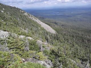
Rock Slide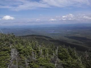
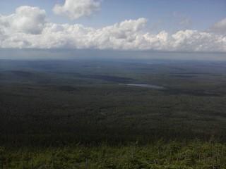
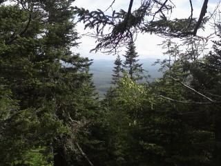
We eventually made it to the summit, and boy was it worth it. The clouds had gone, and the views were amazing for miles. We could see Katahdin, the Bigelows, Big and Little Spencer, Moosehead Lake, and a lot more mountains that I didn't know. In the other direction you could see into Canada, as well as a great view of the town of Jackman.
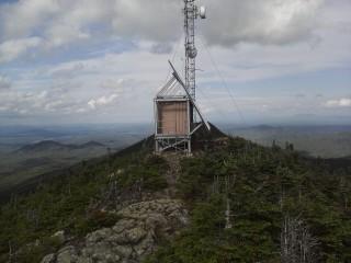
We spent a little time on the summit, but the wind was pretty strong and the storm clouds were moving towards us fast, so we headed down the trail and back to camp. I can't wait to do this hike again next year!
I wasn't sure if we were going to be able to get the hike in. We had to wait for it to stop raining, and the weather was still very unsettled as we arrived at the trail head. It actually started to downpour as we were getting out of the truck. Thankfully it was a very quick shower, and the sun came out right after that.
I had read that the trail was 1.3 miles long, which seemed easy enough. However, where we started from and where the trail is considered to start were not the same point. There was about a 1.5 mile difference. That 1.5 miles was like a walk in the woods. The bugs were insane though. At one point I thought the deer flies and mosquito's were actually going to carry me to the summit!
Once we hit the actual trail, the bugs went away and the work started. The hike was pretty steep and wet. There were slippery rocks and lots of area's where hands were needed to climb. Fun!
Rock Slide
We eventually made it to the summit, and boy was it worth it. The clouds had gone, and the views were amazing for miles. We could see Katahdin, the Bigelows, Big and Little Spencer, Moosehead Lake, and a lot more mountains that I didn't know. In the other direction you could see into Canada, as well as a great view of the town of Jackman.
We spent a little time on the summit, but the wind was pretty strong and the storm clouds were moving towards us fast, so we headed down the trail and back to camp. I can't wait to do this hike again next year!
Difficulty
The trail portion of this hike is pretty tough. I estimate the total elevation gain of 1460 feet. Around 1200 feet is gained in the last 1.3 miles. There are a lot of slippery rocks. Sections of the trail were actually a running stream at the time of our hike. 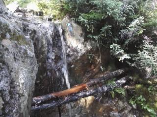
Trail Waterfall 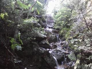
Trail WaterfallA large section was under 4 or 5 inches of water with no other routes possible (my waterproof shoes did not hold up). I would not recommend this hike for kids, or carrying kids in a carrier. I slipped several times going up and down.
Trail Waterfall
Trail Waterfall
Statistics
The hike took a total of 4 hours with 3 people. The total elevation gain 1460 feet, with the summit height being 3640 feet. I would say the round trip hike was 5 1/2 miles.
Images
Images on this page are the property of bemezi2, and may not be used without permission of the owner.

