
Hike Report for Speckled Mountain
Speckled Mountain is located in Maine, United States. It has an elevation of 885 meters above sea level. It is located at the following coordinates: (44.2911, -70.955).
This hike report was written by Douglas Twitchell, about a hike on Monday, August 5, 2013.
This report describes a hike on Bickford Brook Trail
This report describes a hike on Bickford Brook Trail
Directions to Bickford Brook Trail
From Gilead, Maine, take Rte 113 (closed in the winter!) 9 miles south to the Brickett Place, which is a well marked historic site. The trail head is at the back of the parking area. There are also toilet facilities.
Hike Report
The trail from Brickett Place starts out pretty easy; a little uphill at the beginning, but then mostly level for the first half-mile. Somewhere during this stretch you'll see a sign telling you that you're entering the Caribou-Speckled Wilderness, and you should expect to encounter rough and not-well-marked trails.
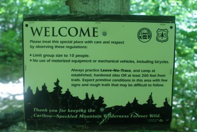
Caribou Speckled Wilderness Notice
Some of the trails are rough, and not all are well marked, but overall, if you're paying attention, you shouldn't have too much trouble.
At 0.6 miles, you have to make a choice - go straight on Bickford Brook Trail for the 3.5 miles to the summit of Speckled, or turn right on the Blueberry Ridge trail for the 0.9 miles to the summit of Blueberry.
I wasn't sure if I wanted to do both mountains, so I figured it made sense to do the shorter one first. I'm glad I did the loop in that direction - the 0.9 miles to the first summit was easily the steepest and most strenuous part of the hike. I'd rather hike UP over a steep section than down. And hiking down over that after having done seven miles around the loop would not have been fun!
When you start down the Blueberry Ridge trail, you really do start "down" - the trail takes you down into a little gorge where (I'm assuming) Bickford Brook runs through. After that it's a very steady climb to the summit of Blueberry.
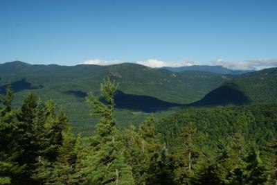
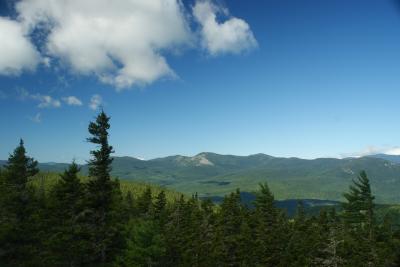
Nice views of the other mountains in the Evans Notch area - especially the Baldface mountains, which are quite dramatic.
South Baldface Ridge
Along the way, watch out for the blueberries! They are some of the sweetest tasting berries you'll find anywhere!
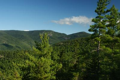
At the top, there is a Lookout Loop Trail, which takes you around the ridge to some places where you can see views in a more south and south-easterly direction. The trail isn't always well marked with cairns, so pay attention!
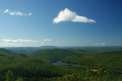
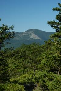
Pleasant Mountain in Bridgton
I don't think Blueberry is actually a "mountain" - I think it's more of an extended arm of Speckled Mountain. Once you reach the summit of Blueberry, you don't actually go back down into a col, as you would between two mountain peaks. Instead, you continue upward at a very comfortable incline along the Blueberry Ridge toward Speckled.
This is a long stretch of hiking here (2.6 miles, I think), and it's important to remember that you won't hit the summit of Speckled until after you've reconnected with the Bickford Brook trail. If you forget that, you'll start thinking, "Oh, I see the summit of Speckled! I'm getting close!"
No, you really aren't. You have to connect to BB first, and then you've got another 0.5 miles to hike after turning right on BB.
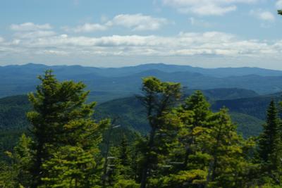
The summit of Speckled is really nice (though it was quite windy today). Views toward Bethel and beyond, as well, as some to the north-east. Two wind farms (Spruce Mtn and Roxbury, I think) are visible from this peak.
View from Speckled
On the way down, I met two hikers coming up the Bickford Brook trail (first people I'd seen all day!) They said that the Bickford trail is like a highway. I wouldn't go quite that far, but it sure was a nice relaxing walk through the woods. 4.2 miles, but no steep hiking the whole way!
Caribou Speckled Wilderness Notice
Some of the trails are rough, and not all are well marked, but overall, if you're paying attention, you shouldn't have too much trouble.
At 0.6 miles, you have to make a choice - go straight on Bickford Brook Trail for the 3.5 miles to the summit of Speckled, or turn right on the Blueberry Ridge trail for the 0.9 miles to the summit of Blueberry.
I wasn't sure if I wanted to do both mountains, so I figured it made sense to do the shorter one first. I'm glad I did the loop in that direction - the 0.9 miles to the first summit was easily the steepest and most strenuous part of the hike. I'd rather hike UP over a steep section than down. And hiking down over that after having done seven miles around the loop would not have been fun!
When you start down the Blueberry Ridge trail, you really do start "down" - the trail takes you down into a little gorge where (I'm assuming) Bickford Brook runs through. After that it's a very steady climb to the summit of Blueberry.
Nice views of the other mountains in the Evans Notch area - especially the Baldface mountains, which are quite dramatic.
South Baldface Ridge
Along the way, watch out for the blueberries! They are some of the sweetest tasting berries you'll find anywhere!
At the top, there is a Lookout Loop Trail, which takes you around the ridge to some places where you can see views in a more south and south-easterly direction. The trail isn't always well marked with cairns, so pay attention!
Pleasant Mountain in Bridgton
I don't think Blueberry is actually a "mountain" - I think it's more of an extended arm of Speckled Mountain. Once you reach the summit of Blueberry, you don't actually go back down into a col, as you would between two mountain peaks. Instead, you continue upward at a very comfortable incline along the Blueberry Ridge toward Speckled.
This is a long stretch of hiking here (2.6 miles, I think), and it's important to remember that you won't hit the summit of Speckled until after you've reconnected with the Bickford Brook trail. If you forget that, you'll start thinking, "Oh, I see the summit of Speckled! I'm getting close!"
No, you really aren't. You have to connect to BB first, and then you've got another 0.5 miles to hike after turning right on BB.
The summit of Speckled is really nice (though it was quite windy today). Views toward Bethel and beyond, as well, as some to the north-east. Two wind farms (Spruce Mtn and Roxbury, I think) are visible from this peak.
View from Speckled
On the way down, I met two hikers coming up the Bickford Brook trail (first people I'd seen all day!) They said that the Bickford trail is like a highway. I wouldn't go quite that far, but it sure was a nice relaxing walk through the woods. 4.2 miles, but no steep hiking the whole way!
Difficulty
If you were just going to Speckled and back, this would be a long but EASY hike - the Bickford Brook trail is on a very steady but shallow incline. Adding in Blueberry Ridge to the hike makes it more challenging because of the steepness of the trail.
For a shorter hike, you can go just up Blueberry and back - that's 3 miles round trip instead of the 8.2 if you do Speckled. However, as mentioned above, it's much steeper!
For a shorter hike, you can go just up Blueberry and back - that's 3 miles round trip instead of the 8.2 if you do Speckled. However, as mentioned above, it's much steeper!
Statistics
I took just over an hour to get to the summit of Blueberry, and then another two hours to get to the summit of Speckled. Once I started down, it was about an hour and a half back to the parking area.
0.6 miles to Bickford Brook Trail/Blueberry Ridge Trail fork
0.9 miles from there to Blueberry Mtn
2.6 miles from there to Speckled
4.1 miles from there down by BB Trail
0.6 miles to Bickford Brook Trail/Blueberry Ridge Trail fork
0.9 miles from there to Blueberry Mtn
2.6 miles from there to Speckled
4.1 miles from there down by BB Trail
Images
Images on this page are the property of Douglas Twitchell, and may not be used without permission of the owner.

