
Hike Report for The Roost
The Roost is located in Maine, United States. It has an elevation of 416 meters above sea level. It is located at the following coordinates: (44.3587, -70.9846).
This hike report was written by Douglas Twitchell, about a hike on Saturday, September 10, 2016.
Not enough votes to display a rating
Directions to Trailhead
From Gilead, Maine, take route 113 south for 2.9 miles. The trailhead will be on your left, and is clearly marked with a sign. There is a small turnout area where you can park your car beside the road.
Hike Report
My son (almost four years old) and I reached the trail head around 8:15 in the morning. It felt very dark, because you are completely overshadowed by trees. The trail starts off fairly steep up some rock stairs, before leveling off almost immediately to a more comfortable walk through the woods.
The trail is well maintained; there were many places along the way that trees had fallen across the trail, and had been sawed up and removed from the trail. In the steeper sections, the trail has eroded until the tree roots are sticking up. The roots aren't a problem though; in many cases they function almost like stairs over the steep parts.
There are yellow blazes along the way, but they are unnecessary; it is never even slightly difficult to follow the trail.
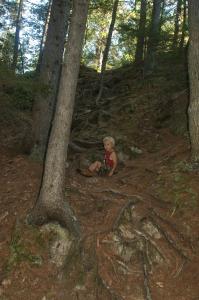
When we reached the summit, I thought I'd been tricked; we reached a wide open ledge that was clearly the peak, and yet the trees were grown up all around, so there was no view. Eventually I turned and looked behind me, and saw a sign pointing to a "scenic view." To get to the scenic view you have to go down over a section that is far steeper (but not super long) than anything you encountered on the way up.
Down to the outlook ledge
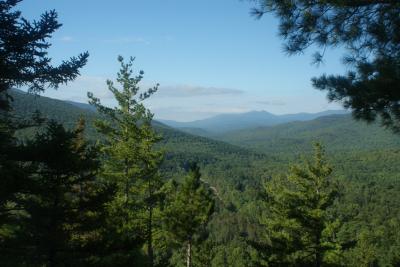
Then you walk through the woods a short while and come to an opening in the trees where you can look south down Evans Notch.
Looking south in Evans Notch
After enjoying the view, we hiked back up to the summit, and then retraced our steps back to the road. You can also continue onward instead of backtracking; there's a second trailhead further down Rte 113. If you do that, you'll need to walk back up the road to your car.
The trail is well maintained; there were many places along the way that trees had fallen across the trail, and had been sawed up and removed from the trail. In the steeper sections, the trail has eroded until the tree roots are sticking up. The roots aren't a problem though; in many cases they function almost like stairs over the steep parts.
There are yellow blazes along the way, but they are unnecessary; it is never even slightly difficult to follow the trail.
When we reached the summit, I thought I'd been tricked; we reached a wide open ledge that was clearly the peak, and yet the trees were grown up all around, so there was no view. Eventually I turned and looked behind me, and saw a sign pointing to a "scenic view." To get to the scenic view you have to go down over a section that is far steeper (but not super long) than anything you encountered on the way up.
Down to the outlook ledge
Then you walk through the woods a short while and come to an opening in the trees where you can look south down Evans Notch.
Looking south in Evans Notch
After enjoying the view, we hiked back up to the summit, and then retraced our steps back to the road. You can also continue onward instead of backtracking; there's a second trailhead further down Rte 113. If you do that, you'll need to walk back up the road to your car.
Difficulty
My son had little problem with this; on the way up he didn't even hold my hand for most of it. On the way down he held my hand for several steep sections, and on the steepest part (near the scenic viewpoint) he went down on his bottom. He's almost four, but he's also done 10 other mountains this year. If you have a child this age, I don't think I would want to make it their first hike.
Statistics
The trail is 0.5 miles long to the summit, if you take the northern trail head. If you take the southern trail head, it's 0.8 miles to the summit. And, if you go up one way and down the other, I was told (but have not verified) that it's about 0.7 miles along route 113 between the two trail heads, which would make it a total of 2 miles hiking.
Images
Images on this page are the property of Douglas Twitchell, and may not be used without permission of the owner.

