
Hike Report for South Baldface
South Baldface is located in New Hampshire, United States. It has an elevation of 1081 meters above sea level. It is located at the following coordinates: (44.2306, -71.0779).
This hike report was written by Douglas Twitchell, about a hike on Thursday, June 20, 2013.
This report describes a hike on Baldface Loop Trail
This report describes a hike on Baldface Loop Trail
Directions to Baldface Loop Trail
From Fryeburg, take 113 north. Note that this is not NH 113 - that's a different route! Follow 113 north about 20 miles, and you will see signs for the trail and parking lot. The parking lot is on the right; the trailhead is on the opposite side of the road, just little bit further down the road.
Note that it's easy to miss a turn on 113; if you do, you end up on 113B, but it eventually reconnects, and you can continue on. Either way it's about 20 miles, but 113 is a better road than 113B.
Note that it's easy to miss a turn on 113; if you do, you end up on 113B, but it eventually reconnects, and you can continue on. Either way it's about 20 miles, but 113 is a better road than 113B.
Hike Report
I hiked this mountain with my father-in-law and several of my brothers-in-law. They wanted a good challenging day hike, and I suggested that this trip would provide the challenge they were looking for.
When you start out your hike, you'll begin with a nice gradual slope through the woods for about 0.7 miles, at which point you will come to a junction of trails, where you can turn left to head toward South Baldface, go straight to get to North Baldface, or turn right to go to Emerald Pool.
I recommend turning left; I've done the loop in the other direction, and coming down over the ledges of South Baldface isn't as much fun.
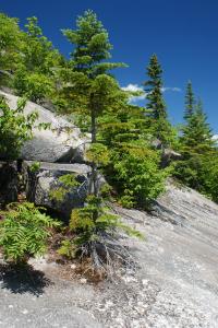
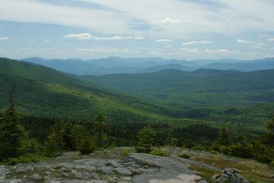
From this point you are about 3 miles from the summit of South Baldface. You'll travel uphill through the woods at a good upward slope, and then you'll break out onto the open ledges that give the mountain its name - Baldface. Since you're going to be out in the open for a long time, you might want to consider some sunscreen; some of my companions were pretty red by the end of the day!
The bald ledges
More bald ledges
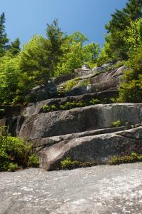
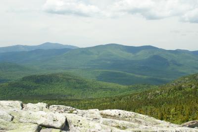
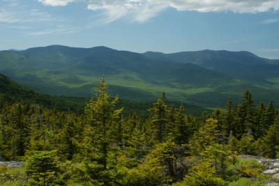
Climbing over the ledges is a lot of fun, but hard work. Whenever you need a break, you should make a habit of turning around and looking behind you; you'll see views of East and West Royce mountains, Pleasant Mountain, and others. It's beautiful.
The Rocyes
At the "top" of the ledges is the "knob." You'll think to yourself, "Oh! That's the summit!" In fact, it's not. You've still got a half a mile of steep climbing to get to the summit.
The Knob
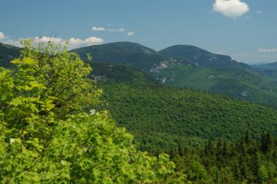
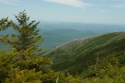
Once you reach the summit of South Baldface, you have magnificent westerly views, including views of Kearsarge North, Chocorua, Mount Washington, and many others.
We stopped here for lunch. Since we were running low on water (bring lots of water - it's a LOOONG hike!), I decided not to eat my rather dry sandwich. Instead I had a couple oranges, and after a bit of rest we pushed onward.
The next phase of the hike is the col between the two peaks. You'll drop steadily downward for a short while, and then the trail levels off. When you look behind you, you'll be shocked at how far you've come from the south peak.
Between the peaks
The hike between the peaks is filled with a lot of ups and downs, culminating with some pretty rugged rocky slopes. At one point one of the guys said, "Hey! Who put this wall here?" Referring to a giant boulder we had to climb over.
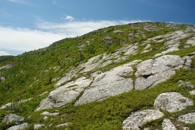
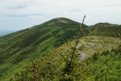
Partway across we got a nice view of the arm of South Baldface - the ledges we climbed earlier:
South Baldface ledges
Finally we reached North Peak. More nice views, and another short break.
On the way down, you'll reach a point where you have a choice between the "Eagle Crag" trail and a Ridge trail. The two trails connect near the bottom of the mountain, so you can go either way. We took Eagle Crag, which led us out onto some more open ridges with nice views.
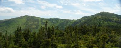
Both peaks
Then, all of a sudden, you start dropping rapidly. There is one very steep section, but fortunately it is not long. Then it's just a relaxed (but long) trek through the woods.
Eventually you come back to that junction by Emerald Pool - this is where many people, after a long hike, go for a dip. We opted to go straight back to the parking lot.
It was beautiful but challenging hike over a couple great mountain peaks.
When you start out your hike, you'll begin with a nice gradual slope through the woods for about 0.7 miles, at which point you will come to a junction of trails, where you can turn left to head toward South Baldface, go straight to get to North Baldface, or turn right to go to Emerald Pool.
I recommend turning left; I've done the loop in the other direction, and coming down over the ledges of South Baldface isn't as much fun.
From this point you are about 3 miles from the summit of South Baldface. You'll travel uphill through the woods at a good upward slope, and then you'll break out onto the open ledges that give the mountain its name - Baldface. Since you're going to be out in the open for a long time, you might want to consider some sunscreen; some of my companions were pretty red by the end of the day!
The bald ledges
More bald ledges
Climbing over the ledges is a lot of fun, but hard work. Whenever you need a break, you should make a habit of turning around and looking behind you; you'll see views of East and West Royce mountains, Pleasant Mountain, and others. It's beautiful.
The Rocyes
At the "top" of the ledges is the "knob." You'll think to yourself, "Oh! That's the summit!" In fact, it's not. You've still got a half a mile of steep climbing to get to the summit.
The Knob
Once you reach the summit of South Baldface, you have magnificent westerly views, including views of Kearsarge North, Chocorua, Mount Washington, and many others.
We stopped here for lunch. Since we were running low on water (bring lots of water - it's a LOOONG hike!), I decided not to eat my rather dry sandwich. Instead I had a couple oranges, and after a bit of rest we pushed onward.
The next phase of the hike is the col between the two peaks. You'll drop steadily downward for a short while, and then the trail levels off. When you look behind you, you'll be shocked at how far you've come from the south peak.
Between the peaks
The hike between the peaks is filled with a lot of ups and downs, culminating with some pretty rugged rocky slopes. At one point one of the guys said, "Hey! Who put this wall here?" Referring to a giant boulder we had to climb over.
Partway across we got a nice view of the arm of South Baldface - the ledges we climbed earlier:
South Baldface ledges
Finally we reached North Peak. More nice views, and another short break.
On the way down, you'll reach a point where you have a choice between the "Eagle Crag" trail and a Ridge trail. The two trails connect near the bottom of the mountain, so you can go either way. We took Eagle Crag, which led us out onto some more open ridges with nice views.
Both peaks
Then, all of a sudden, you start dropping rapidly. There is one very steep section, but fortunately it is not long. Then it's just a relaxed (but long) trek through the woods.
Eventually you come back to that junction by Emerald Pool - this is where many people, after a long hike, go for a dip. We opted to go straight back to the parking lot.
It was beautiful but challenging hike over a couple great mountain peaks.
Difficulty
This is a good hike for adults who are in good physical condition. It's a long and arduous hike for someone who is not in good shape. The youngest member of our hiking party was 12 years old, and he had previous experience on long hikes. I wouldn't want to take someone younger/inexperienced on this hike.
Statistics
The Loop Trail hike is about 10 miles long (the signpost says 9.8 miles). During that 9.8 miles, you will summit two challenging peaks - South Baldface, followed by North Baldface.
You can do the loop in the opposite direction (starting with North and going to South), but in my opinion, that's the harder way to do it. Going down over the steep rock ledges on South Baldface requires a lot of sliding on your butt!
You can do the loop in the opposite direction (starting with North and going to South), but in my opinion, that's the harder way to do it. Going down over the steep rock ledges on South Baldface requires a lot of sliding on your butt!
Images
Images on this page are the property of Douglas Twitchell, and may not be used without permission of the owner.

